WWW.
West Woods Wetland
may 30, 1997
K. Harp
S. Luck
B. Morris
K. Woodruff
TABLE OF CONTENTS
Title Page
Abstract 1
Introduction 2
Materials and Methods 3
Data and Results 4
Summary and Discussion 5
References 6
Abstract
Harp,K., Luck,S., Morris,B., Woodruff,K. 30 May 1997. West Woods
Wetland.
In an attempt to determine the suitability of the West Woods
area to sustain a wetland, the following experiments were
performed: the width, length, and directional changes of West
Woods creek were measured. The numbers and species of all
invertebrates viewed in a swampy area, a grassy area, and a
ravine that were found within a time was calculated, and then
specified, and the total number of organisms , total number of
species, and percentage of plots that the species were found in
were also calculated. Similar experiments were performed
involving shrubs and herbaceous plants. The percent relative
density was also found. Environmental factors including wind
speed at head and ground height, soil temperature, air
temperature, wet and dry, and light intensity at low medium and
high exposure. Soil from the black morel area, the creek, the
marsh, and alongside the ravine was collected. The components of
the soil were separated and measured. The results of all
experiments can be found on the Clermont College Home page.
INTRODUCTION
Clermont College is expanding their campus with the
construction of a new building. The expansion will not only
provide a new building for indoor learning but also a wetland
area to enhance students' learning in nature's classroom. There
are a number of factors that must be taken into account to
determine the most advantageous site for the wetland development.
Azimuth compass reading along with a measuring tape are used to
plot the existing creek that runs through the potential wetland
site. A transit can be used to measure land elevation and to
determine the height of the existing forest canopy. Soil tests
are an excellent way to determine if the soil is an appropriate
texture to sustain an aquatic habitat. Environmental factors
such as relative humidity, wind velocities, soil temperature, and
light intensity are very important factors in determining if the
selected area will make an appropriate wetland region. Data
collection of the existing habitat of insects, arthropods, trees,
shrubs, and herbaceous plants will help determine what changes
occur over a period of time in and around a wetland region. The
expansion of the college campus will inevitably destroy some of
the wildlife and woodland that is presently residing on the
existing campus. Will the new wetland habitat be enough to make
up for the loss?
1
Literature Review
The preservation of the West Woods has long been an issue at
Clermont College and has repeatedly been threatened by campus
expansion. The expansion is now inevitable and there is talk of
construction of a wetland to replace the destroyed woods.
Numerous experiments and studies have been performed on West
Woods by previous ecology, biology, and geology classes. The
results and data from these studies are available from Dr.
Fankhauser and Mrs. Carter, but was not readily available to be
included in this paper. West Woods has offered an excellent
opportunity to study various ecosystems due to the fact that
there are many types there. Our ecology class was able to study
the environmental factors of the forests, grasslands, and
wetlands that exist on the college campus. The data collected in
these areas, which are available within this article, is
important because the creation of a new wetland will greatly
change these environmental factors. Wetlands have been
constructed by groups not related to Clermont College. The data
and results of these constructed wetlands are available on the
Internet at the addresses listed on the reference page.
2
Methods and Materials
The stream behind the side parking lot located in West Woods
was mapped from the sight it hits the trail to the point where
the UC road interferes. Flags were used as marks to designate
straight segments in the stream. Distance was measured between
each flag and the width of the stream and azimuth was calculated
at each flag. [see Carter's Mapping Protocol 1997] Using the
distance and azimuth readings a map was plotted. A transit was
also done. [see Carter's Mapping Protocol 1997]
Only measuring tapes and flags were used while conducting
the Flora and Fauna experiment during the shrub and herb plot
sections. At that time the class separated into two groups and
each measured 4x4m shrub plots in the swamp area and the woods.
In each plot, trees, saplings, vines, etc. within that area were
identified. Invertebrates were counted in the swamp area, grassy
area, and creek area (forest). The ground was examined closely.
Logs and surrounding "litter" were examined for specimens (turned
over and replaced), and flying insects were identified as seen.
Evidence of birds and other vertebrates were collected by
identifying songs and droppings. Later, in the classroom, charts
were completed, noting the number\kind of species in each area.
Total number of plots were calculated for this experiment, and
the percent of plots for each specimen was recorded. To obtain
the percent of plots the number of plots was divided by the total
number of plots. The number of species in a time spand of an
hour was calculated differently according to the time spent at
each area. Invertebrates were multiplied by 3\2 in the creek, 3
in swamp area, and by 2 in the grassy area to collect the total
number of organisms (in an hour).
While analyzing soil, a mechanical analysis, subjective
analysis, and soil chemical identification was done on soil
samples from side of ravine, creek, morel area, and swampy area.
For the mechanical analysis, soil and Calgon water softener were
weighed, pulverized, stirred, repeatedly decanted, dried, and
finally sieved using a seven section sieve set (from 2mm to less
than 63um). [see Carter's Soil Analysis Protocol 1997] Subjective
analysis was carried out by adding a small amount of water and
noticing the ability of the soil to form a ribbon. Finally, soil
chemical identification was done with a soil test kit provided to
the class. [see directions within soil testing kit]
Tree Analysis was carried out in two groups in the
ravine\woods. Along an undetermined path the closest, biggest
tree was found, identified, and DBH (diameter at breast height)
was measured using either a regular measuring tape for one group
or a tree measuring tape for the other. Next the same was done
to another tree after turning 180 degrees and finding the
closest, biggest tree. The distance between trees was
calculated, and the procedure repeated 20 times in each group,
with ten steps in between each site. [see Carter's Tree Analysis
Protocol 1997] In receiving the numbers for DBH when using the
regular measuring tape, the numbers for each were divided by pi.
Another chart was constructed containing number of trees, percent
of trees (number of individual trees divided by total trees), sum
DBH, average DBH, area, and area x percent trees x number of
trees.
Environmental factors were collected from the following
areas: edge of back parking lot, tall grass field, wet swamp,
back of woods, morel woods, beech-maple forest, and creek of
beech-maple forest. In each area light intensity, air
temperature, soil temperature, and wind velocity were recorded.
Light intensity was measured in areas of high, medium, and low
light. Air temperature was recorded using a wet bulb and dry
bulb thermometer. Before examining the last two areas (in beech-maple forest) the thermometer had to be changed because it had
been broken. The same sock was used on different thermometer.
The wind velocity was collected at head height and ground height.
In every area the dew point temperature and relative humidity
were obtained by using a psychrometer. [see Carter's
Environmental Factors Protocol\Psychrometer portion 1997]
3
DATA AND RESULTS
The data and results of the following: mapping of the creek,
flora and fauna of the area, tree analysis, environmental
factors, and soil analysis of the area all followed the
procedures in the materials and methods section.
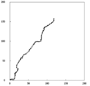 Mapping of the Creek: The results from the 57 measurements
in length gave a total of 220.29 M. The measurements were taken
in the middle of the creek, following all bends. Taking compass
readings at each of these areas gave us the direction the creek
was bending. The width of the creek ranged from 3.74 M. to
0.93 M,with an average of 1.66 M. Putting all the data into
Lotus, a GRAPH was constructed showing the contours of the creek
along with widths.
Mapping of the Creek: The results from the 57 measurements
in length gave a total of 220.29 M. The measurements were taken
in the middle of the creek, following all bends. Taking compass
readings at each of these areas gave us the direction the creek
was bending. The width of the creek ranged from 3.74 M. to
0.93 M,with an average of 1.66 M. Putting all the data into
Lotus, a GRAPH was constructed showing the contours of the creek
along with widths.
Flora and Fauna: The data collected from the invertebrate
counting took place at the swampy area, the grassy area above the
swamp, and along side of the creek. The results showed that
spiders were the most frequent invertebrate with a total of 53
found in all 3 areas. The next two highest found in all areas
were the other flies with 24.5 and a tie between butterflies and
ants at 20.5. Check the insect, arthropods, and other
invertebrates TABLE for the full list of invertebrates and where
they were found.
Two groups collected the data set for the
shrub and herb plots,
which took place at the swampy area and the woods by the
creek. The plant species that was found in both areas by both
groups was the wild rose at 28 plants. The ever present poison
ivy was the next with 23 plants, found in two areas by one group
and in on area by the other. The shrub plots TABLE has the
complete listing of all plants found and their numbers. The herb
plots were done in the same area as the shrub plots but a smaller
sized plot. Grass was the largest in all areas with 33 clumps.
The next highest in the herb plots was the common chickweed with
32 plants, but was only found in the woods area. The herb plots
TABLE, like the shrub plot table, also has a complete listing of
all herbs and their numbers.
Tree Analysis: The results from the data collected from the
tree analysis of the ravine area showed 12 different types of
trees. The predominate trees of the area include: black cherry,
green ash, and red maple. A TABLE, has been constructed with all
the different types of trees with their D.B.H.(diameter at breast
height), and the distance from other trees. A pie GRAPH was also
made to show the distribution of numbers of trees. From
calculating the percent of trees, cherry is the most dominant
over other species of trees at 41.60%.
Environmental Factors: The data was collected from the
following areas: parking lot backfield, grassy hill, the marsh,
the back of the woods, morel area, the beech/maple area, and the
creek area. The environmental factors pertain to the light
intensity, temperature, percent relative humidity, and wind
velocity. The area with the highest light intensity in the high
range was in the parking lot backfield. The highest in the medium
range was at the grassy hill, and for the low range the marsh had
the highest milliphot.
The temperature was measured with a wet and dry bulb
thermometer, and the soil with a soil thermometer. The wet and
dry bulbs stayed changing the same until the beech/maple area ,
where the wet bulb temperature went down and the dry bulb went
up. The soil temperature changed dramatically from the marsh at
19 C to 11 C in the back of the woods.
The percent relative humidity stayed relatively the same
until the beech/maple area when it dropped from 63-57% to 27%.
The wind velocity was checked at both head height and ground
height at centimeter per second. The head height reading dropped
to 0 at the morel area, and it dropped and remained at 0 at the
back of the woods area at ground height.
The data TABLE and the GRAPHS of the light intensity,
temperature, percent relative humidity, and wind velocity, show
all other data and appropriate information.
Soil Analysis: The soil analysis of the areas of: side of
ravine, creek soil, morel soil, and the swampy area. Three out
of the four areas were 40% or more clay soil. The swampy area
was the only area with 27-40% clay loam soil. The TABLE shows
the results for the rest of the areas and also includes
mechanical and soil chemical results.
4
Summary
The stream\creek area in West Woods will be a sufficient
area to create a wetland. The five experiments that were
performed all contributed to the understanding of the
environmental conditions of the West Woods region. The following
experiments were done: Mapping of West Woods creek, Tree
analysis, Flora and Fauna, Soil analysis, and Environmental
factors.
The first experiment performed involved the mapping of the
creek that runs through the studied region. This experiment
provided information that accurately represents length, width,
and direction of the creek. Creating this map allows us to
determine the ideal areas for construction on creating the
wetland.
Random Pairs Tree analysis and Flora and Fauna experiments
provided us with information about the existing plants and
insects in West Wood. This research on the existing wetland may
also give an insight as to what new wildlife may develop.
The Environmental factors in West Woods are appropriate to
sustain a wetland for a number of reasons: it would provide an
excellent area of study for future Clermont students, as well as
an opportunity to expand the Biology department. The soil is
excellent for the purpose of a wetland, being 40% or more clay.
Also, the forest consists mainly of mature cherry and ash trees ,
with a few exceptions. These trees are abundant in this area and
would not be detrimental to remove them. Thus, constructing a
wetland would likely not entirely kill off any species of trees.
Soil analysis was the final experiment performed. This
allowed us to determine the components of the soil in various
areas of West Woods. Through objective analysis, we determined
that the soil in West Woods is 40% or more clay which is
necessary to sustain a wetland.
There are, however, some negative effects of creating a
wetland. Some of them are- the possible stench from the wetland,
the task of maintaining it. The standing water could cause a
apartment complex. There is also the possibility of an increase
in the annoying insect population. These factors were weighed
carefully when considering a constructed wetland. The conclusion
reached is that the construction of a wetland would be more
beneficial than detrimental, and the construction should be
performed.
5
REFERENCES
Carter, Janet S. Environmental Factors. 1997.
Carter, Janet S. Flora and Fauna. 1997.
Carter, Janet S. Mapping: Use of Compass and Transit. 1997.
Carter, Janet S. Random Pairs Tree Analysis. 1997.
Carter, Janet S. Soil Analysis. 1997.
LITERATURE REVIEW INFO CITES
Cajun Wetland Guide Service
http://www.geocities.com/BourbonStreet/8013.html
Constructed Wetlands. http://www.eng.auburn.edu/~paytoid/wetland.html
SWAMP Constructed Wetland. http://www.computan.on.ca/~prodigal/ftgeo3.htm
6